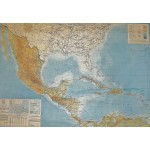
Mexico, Central America, and the West Indies: Map of the Americas (Large pull down color map)
Click Image for Gallery
Mexico, Central America, and the West Indies: Map of the Americas (Large pull down color map)
American Geographical Society of New York
American Geographical Society of New York, 1942
86 x 116 cm. Mounted on muslin, wood rods top and bottom. Minor toning. Scale 1:5,000,000 ;, Bipolar oblique conic conformal projection, (W 107--W 60/N 32--N 4). Depths shown by spot heights and bathymetric isolines. Includes key map, text, Explanatory Notes and table of scale conversions.
Note: This is a large, heavy map. Additional postage will apply depending on delivery location.


