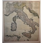
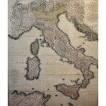
(Composite of) Italy with the Addition of the Southern Parts of Germany as Far as Pettau in Stiria; Murlakia, Dalmatia, the Adjacent Countries, and All the Illyric Islands (Extremely Large Map)
(Composite of) Italy with the Addition of the Southern Parts of Germany as Far as Pettau in Stiria; Murlakia, Dalmatia, the Adjacent Countries, and All the Illyric Islands (Extremely Large Map)
Delarochette, Louis Stanislas d'Arcy; Faden, William
Published by Willm. Faden, Geographer to the King and to H.R.H. the Prince of Wales, Charing Cross, September 12th, 1816; Delarochette, 1816
Very large and attractive hand-colored map of Italy. The various Italian states are listings. Also includes Corsica, Sardinia, Sicily, Malta, Slovenia, Croatia, Dalmatia, Southern Germany, Austria, Switzerland, Northern Africa, etc. The map shows roads, towns, rivers, lakes, islands, ports, harbors and major topographical features. Dimensions in frame: 153 x 137.5 cm. (60 1/4 x 54 1/4 inches). Dimensions of the map: 128 x 112 cm. 7 x 5 sections, laid on linen. Initially printed in two sections. Refs: Phillips 6010, 6013, 6047. David Rumsey, 2104.028 (citing 2nd edition). From William Faden's General Atlas of 1816. First published in 1800, this new map reflects the political changes after the Napoleonic conquest of Italy.


