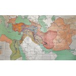
Die Kulturreiche des Alten Orients (Large Pull Down Map)
Click Image for Gallery
Die Kulturreiche des Alten Orients (Large Pull Down Map)
Siegfried Lauffer
Perthes, Darmstadt, 1976
[Historical Map of Asia Minor] 198 x 125 cm. Mounted on linen, wood rods top and bottom. Scale 1:2750000. Shows ancient kingdoms and states dominated the Middle East from the 3rd to the 1st century B.C. (2300-500 B.C.), boundaries, principal cities, and routes. Relief shown by shading. Cities ancient names are in bold letters and modern names in light letters or within parentheses. Note: This is a large, heavy map. Additional postage will apply depending on delivery location.


